HONOLULU (KHON2) – The weak boundary approaching from the northwest will stall and dissipate northwest of the coastal waters through the remainder of the weekend.
Otherwise, a weak subtropical ridge axis will remain over or near the islands with weak ridging aloft through the middle of next week.
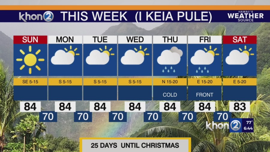
Winds will become light and variable over much of the state Sunday into Monday, then remain on the lighter side through Wednesday.
During this time, expect clouds and showers to focus over the mountain and interior areas of each island due to sea breeze development during the late morning/early afternoon each day.
Rainfall amounts will be light due to the large scale atmospheric stability.
By Thursday, long-range model guidance continues to show a shallow cold front creeping into the western islands from the northwest.
While the GFS and ECMWF still differ on the speed of the front, increased showers and breezy trade winds will develop along the weakening boundary as it progresses eastward.
All islands will likely benefit from a period of enhanced showers along the frontal band, especially along the windward mountain slopes.
Both models have the front stalling out near Maui by Friday morning and breaking up/dissipating by the afternoon, with remnant unstable cloud bands drifting into each island on the strengthening easterly trade winds.
The global models both indicate another front approaching the state from the northwest Saturday night into Sunday, uncertainty remains whether the boundary makes it to the islands before dissipating.