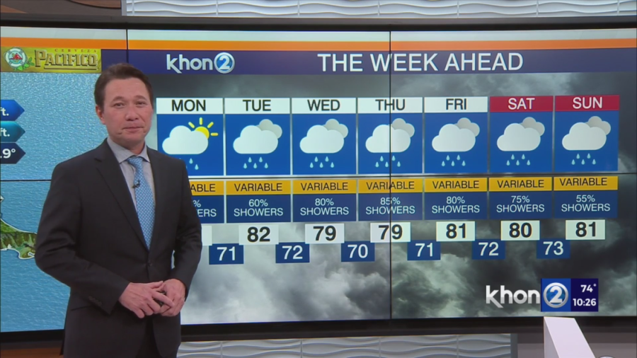
HONOLULU (KHON2) — Gentle trade winds are expected to shift towards the southeast over the next few days, maintaining a familiar pattern of kona winds. This pattern will bring clouds and showers inland, followed by clearing skies and offshore showers at night. The southeasterly winds will strengthen bringing higher dewpoints of upper 60s to near 70 degrees by Monday night, likely persisting throughout the week.
As the low forms near the islands, the winds over the islands will shift to southwesterly by Tuesday night, leading to increased showers. Surface winds will remain light, possibly resulting in offshore showers due to island land breezes. By Wednesday, a south to southwest wind flow will prevail, increasing the likelihood of showers for all areas.
The converging southwest flow will bring moderate to potentially heavy rainfall over the islands starting as early as Wednesday night and continuing into the weekend. Differences arise in the guidance for the weekend, particularly regarding the interaction of the resident kona low with additional energy from the northern branch of the jet stream. This could significantly alter the location of the heavy rain band. The main takeaway is that there is an elevated risk of heavy rain and potential flooding from Wednesday through the weekend, perhaps even longer.
Trade wind have vanished and with Kona winds taking over, it will feel very humid this week.