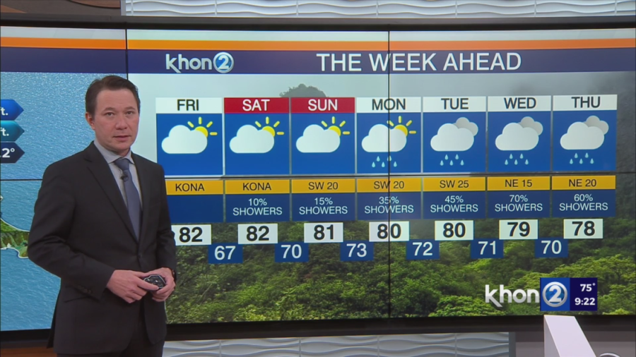
HONOLULU (KHON2) — The trades winds are being replaced as kona winds take over. By Sunday through much of next week, southwesterly winds will strengthen. A weakending cold front is expected to increase rain chances across the board. Wetter conditions will last much of next week.
Today & Tomorrow:
- Weakening Trades: Trade winds will decrease in strength and shift direction towards the southeast.
- Hybrid Weather: Expect a mix of:
- Windward Showers: Limited showers on the windward sides.
- Leeward Breezes: Isolated showers due to sea breezes in sheltered areas.
This Weekend:
- Continued Trade Weakening: Trades will further weaken and shift to southerly and then southwesterly directions.
- Increased Breezes: More widespread land and sea breezes.
- Daytime Clouds & Showers: Limited showers and clouds in leeward and interior areas during the day.
- Nighttime Clearing: Mostly clear skies at night.
Next Week:
- Mid-Week Front: A cold front will arrive by mid-week.
- Increased Rainfall: Expect some beneficial rain.
- Stronger Winds: Breezy north-northeasterly winds, especially in the western part of the state.
- Continued Showers: Rain chances will persist due to the front and additional moisture.
Volcanic Activity:
- Big Island Hotspot: Volcanic activity continues at Halemaumau Crater.
- Vog Potential:
- Tonight/Tomorrow: Vog may increase across some smaller islands as winds shift.
- Big Island Impact: Vog will primarily affect portions of the Big Island and nearby waters.