HONOLULU (KHON2) – A jet stream along the eastern flank of this system will bring cirrus clouds over much of the state, particularly the western half into Monday.
At the surface, a weak high is located about 2000 miles to the east, with a long ridge axis that passes just north of Hawaii.
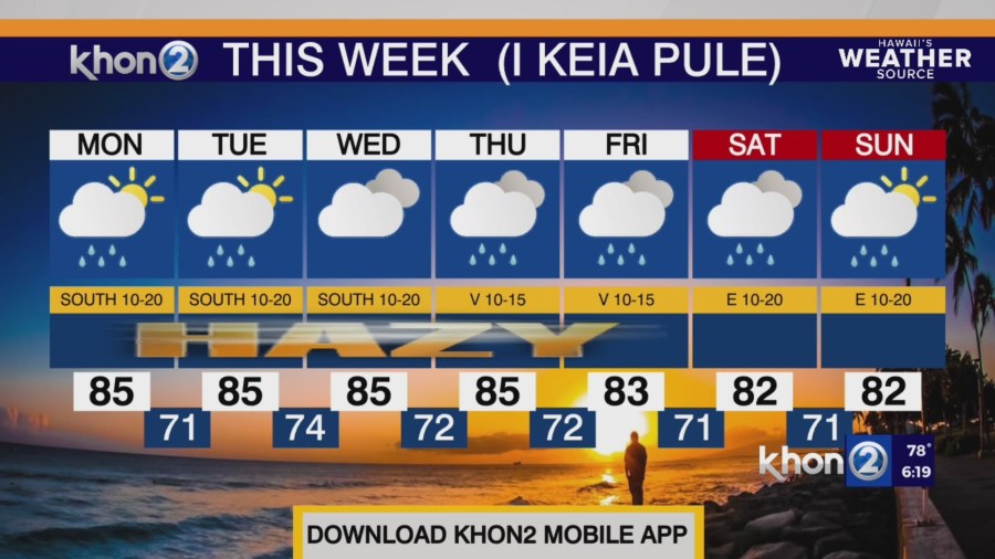
Gentle southeast winds will be the result of the ridge to the east tonight with land breezes decreasing low clouds over the island interiors tonight.
Vog will carry up from the Big Island to the smaller islands over the next several days.
The low pressure system and associated cold front will begin to move closer to the islands Monday and Tuesday.
Southerly winds will strengthen and bring increased moisture initially over the western end of the state as early as tonight and over the next few days.
Clouds and showers will focus over leeward and south facing slopes (southeast for Big Island).
Winds will taper off and veer southwesterly as the front nears the western end of the state allowing land and sea breezes to take over again.
The front may reach Kauai around Thursday and begin to stall and weaken into Friday with trade winds filling in over the frontal boundary, potentially leading to more widespread rainfall into next weekend.
Small Craft Advisory from noon Monday to 6 PM HST Tuesday for Kauai Northwest Waters, Kauai Leeward Waters, Big Island Windward Waters, Big Island Leeward Waters.