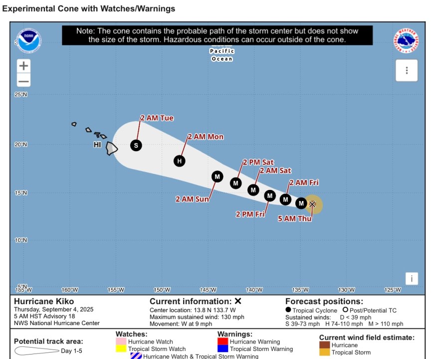
HONOLULU (KHON2) — As Hurricane Kiko inches toward the islands, the storm is expected to lose some traction once it crosses into the Central Pacific Basin.
Kiko is now up to a Category 4 storm, moving toward Hawaiʻi at 9 mph with consistent winds at approximately 130 mph. This weakened slightly over the morning of Sept. 4, with early morning reports of Kiko having windspeeds of approximately 145 mph.
The hurricane is expected to enter the Central Pacific Basin tomorrow, Sept. 5, which contains colder water than the part of the Pacific Kiko is coming from. As he crosses into and through the basin, experts forecast that he will weaken down to a Category 3, and eventually Categories 2 and 1 if he makes landfall.
While the exact path and timeline of the storm is not exact, once Hurricane Kiko makes his way fully into the Central Pacific Basin, experts will have a much clearer idea as to his path and lifespan.
Should Hurricane Kiko make contact with Hawaiʻi, effects would peak from Monday, Sept. 8 through Wednesday, Sept. 10. If he takes a northerly path, effects include a halt to the high pressure system and trade winds, and of course wet weather.
For continued coverage on Hurricane Kiko, stick with Hawaiʻi’s weather team of Brittni Friedlander, Justin Cruz and Kamaka Pili as the trio covers Kiko’s path daily on KHON2.