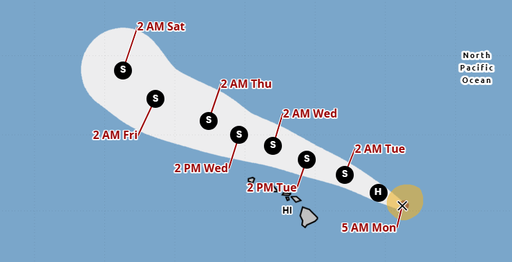
HONOLULU (KHON2) — Hurricane Kiko has been downgraded to a Category 1 hurricane on Sept. 8 as the storm’s path travels around the islands, avoiding direct contact with Hawaiʻi.
Kiko is traveling in a northwestern direction at 15 mph, with sustained winds currently at 85 mph. The storm’s apparent path takes it north of Hawaiʻi, which does come with its own challenges.
According to experts, the storm’s path comes with some high surf for east-facing shores on the islands, with high surf advisories or even warnings expected in the coming hours.
Additionally, Kiko’s path will bring a halt to the trade winds on Tuesday and Wednesday, which could increase humidity around the islands.
Hurricane Kiko is expected to drop down to a tropical storm in the coming days, before the peak of his impacts reach Hawaiʻi.
We’re Hawaii’s weather station, get the latest forecast and radar information here
Given its path, Kiko’s “peak” effects are not comparable to a direct hit from a hurricane. In addition to high surf and disrupted trades, experts expect wet weather and winds, albeit not at an intense strength.
Since crossing into the Central Pacific Basin, Kiko’s threat of a direct impact has significantly decreased, preventing more intense weather conditions across the islands.
For continued coverage on Hurricane Kiko, stick with Hawaiʻi’s weather team of Brittni Friedlander, Justin Cruz and Kamaka Pili as the trio covers Kiko’s path daily on KHON2.