HONOLULU (KHON2) – Latest radar and satellite imagery shows heavy showers and isolated thunderstorms moving over the island of Oahu this afternoon, with lighter rain observed over Kauai.
This moisture is being drawn northward by a kona low that is located northwest of the main Hawaiian Islands with a trough located near Kauai.
Additionally, surface convergence from more easterly flow across the central islands and southerly flow wrapping around the southern tip of the Big Island has sparked convection within an unstable environment over the western portion of the state.
This is resulting in the occasional heavy showers and isolated thunder observed over Oahu today.
Some of the hi-res guidance has been hinting at this possibility over the past day or so as we transition from the southerly flow back to easterly flow.
A Flood Watch remains in effect for Kauai County through tonight as pockets of heavy rain will remain possible.
Additionally, convergence upstream of Oahu could continue to produce occasionally heavy showers moving into Oahu into the evening, but should trend down during the overnight hours.
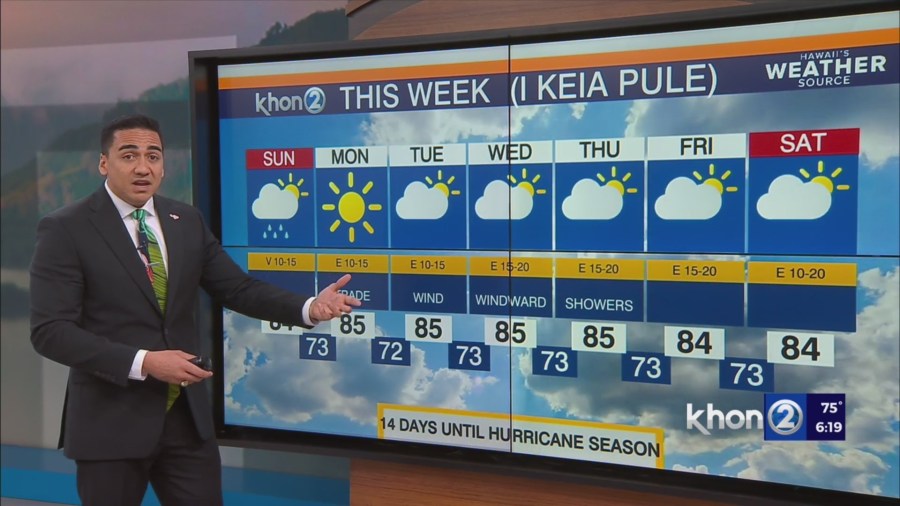
High pressure will build in from east to west across the state Sunday as the kona low shifts north and weakens.
Expect more stabilizing trends with decreasing showers as east to southeast winds spread across the state on Sunday.
By Sunday, the moderate to heavy rainfall threat will diminish as more stable conditions fill in across the state.
Easterly trade winds will return across the islands from Monday onward.
Trade wind showers may be somewhat enhanced during the first half of next week due to lingering moisture and some upper level instability from a short wave trough.
Precipitable water values will return to normal during the second half of the week, supporting a more typical trade wind pattern.