HONOLULU (KHON2) — Hurricane Kiko is expected to cross into the Central Pacific Basin this evening, Sept. 5, with effects from the storm anticipated to be felt on the islands from the night of Monday, Sept. 8 through Thursday, Sept. 11.
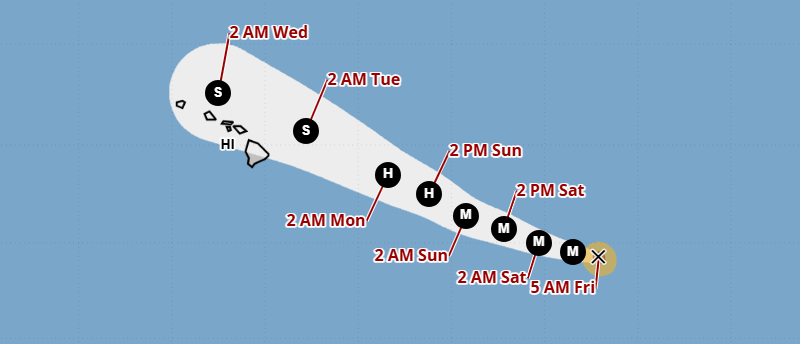
Kiko is maintaining his Category 3 status, which was downgraded from a Category 4 last night, Sept. 4. The storm is making its way toward Hawaiʻi at 9 mph with windspeeds of 115 mph.
While original forecasts saw Kiko regaining some strength back to a Category 4, updated forecasts show that he will maintain his Category 3 status for the day as he crosses through the Central Pacific Basin toward the islands.
Given the cooler water surrounding Hawaiʻi, Kiko is expected to downgrade to Categories 2 and 1, then to a tropical storm before making landfall on the Big Island.
Tropical storms come with relatively slower windspeeds, with speeds under 74 mph being considered a tropical storm.
While the exact path is still undetermined, it appears as if Kiko is most likely going to travel along the northern side of the islands. Should this happen, Hawaiʻi can expect to see wet weather and halt to the trade winds.
There is a small chance that Kiko travels south of the islands, which would in turn cause less effects, but this is not a likely scenario.
Kiko’s exact path will be clearer once he makes his way fully into the Central Pacific Basin.
For continued coverage on Hurricane Kiko, stick with Hawaiʻi’s weather team of Brittni Friedlander, Justin Cruz and Kamaka Pili as the trio covers Kiko’s path daily on KHON2.