HONOLULU (KHON2) — A weak low pressure system is currently located about 750 miles northeast of Oahu and is slowly moving southwest. Its associated trough is stalled over the waters about 100 miles north-northeast of Kauai.
Expect clear skies tonight, as mauka drainage winds will clear most of the late-day clouds, though some clouds may linger along high ridges and leeward Big Island areas where moisture can be trapped.
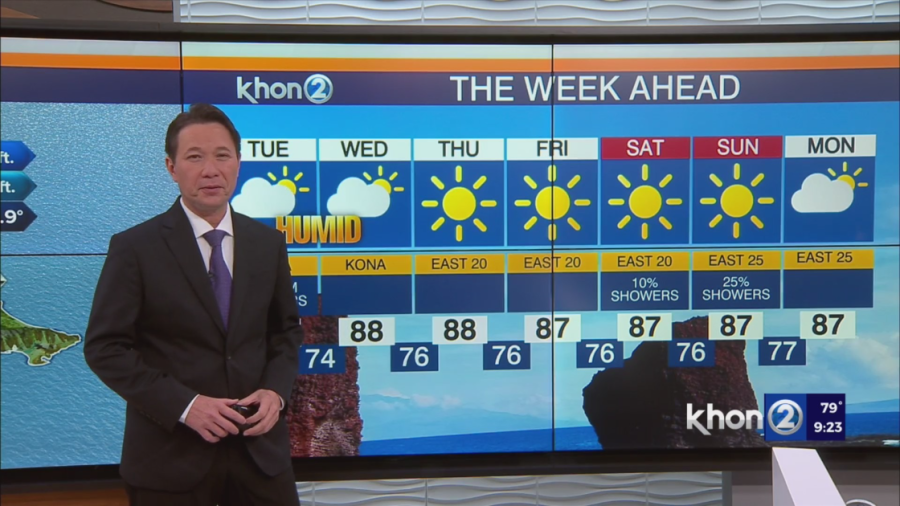
The increased moisture near the weak boundary will lead to light and variable winds statewide and higher chances of rain in the western part of the state over the next day or so. Expect more showers in the Big Island Kona region in the afternoon due to a sea breeze boundary. Lower elevations will feel slightly more humid with temperatures reaching the mid-80s.
Light and variable winds will continue over the islands through mid-week due to the weak boundary north of Kauai. The low pressure system far north of the islands will weaken and move northwest through Wednesday, leading to the dissipation of the weak surface trough by Thursday. Breezy trade winds are expected to return from Thursday afternoon into the weekend. However, moisture from the east will increase, leading to a rise in rain chances. By the weekend, the return of trade winds will bring more frequent overnight showers and greater rainfall, especially along windward areas and higher elevations.