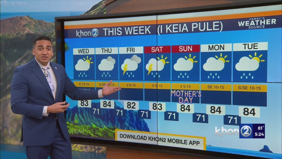
HONOLULU (KHON2) – In the short term, the trade winds will continue to weaken further tonight into Wednesday with sea breezes expected over leeward areas by Wednesday afternoon.
Starting Thursday, the atmosphere will begin to change as an upper level low approaches the state.
The surface winds will likely weaken further as a surface trough begins to develop over the state. Temperatures aloft will begin to cool, which will bring instability over the state.
With the added instability, some low level moisture, and sea breeze convergence, showers should increase during the afternoon on Thursday over interior and mountain areas.
Due to light winds in the lower half of the atmosphere, any showers that develop will be slow moving and will be capable of producing some downpours in the afternoon.
Although some locally heavy showers will be possible Thursday afternoon, the main concerning period will be Friday through Saturday.
An unusually cold upper level low will approach the state Thursday night and is expected to be over or very close to the state by Friday afternoon.
This will produce a very unstable weather pattern for Friday and will allow for any showers that do develop to become a heavy rain threat.
Also, with temperatures that cold aloft, we will likely see isolated thunderstorms with some of the stronger storms capable of producing small hail.
At this time, it is too early to tell exactly where the heavier showers and thunderstorms will develop, and it will highly depend on the position of the upper level low.
Although the details are still uncertain, the main takeaway is that we are not expecting a widespread rain event.
But, any showers that do develop on Friday will be capable of producing intense rainfall rates.
With the potential for intense rainfall rates and the slow movement of any showers or thunderstorms, a Flood Watch could be issued in the coming days.