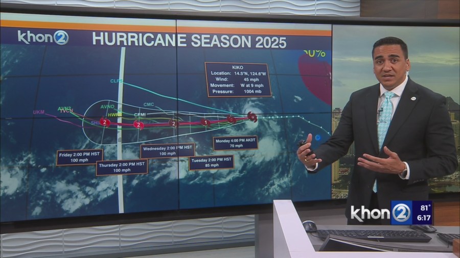
HONOLULU (KHON2) – At 500 PM HST, the center of Tropical Storm Kiko was located near latitude 14.5 North, longitude 124.6 West.
Kiko is moving toward the west near 9 mph (15 km/h), and this general motion is expected during the next few days.
Maximum sustained winds have increased to near 45 mph (75 km/h) with higher gusts.
Steady strengthening is expected, and Kiko is forecast to become a hurricane in a day or two.
A weakened trade wind inversion around 8kft is observed which matches well with radar-indicated shower tops penetrating to 10kft or so.
Interior showers developed over the islands this afternoon in response to daytime heating with the resident envelope of low-level moisture, but they have largely been disorganized.
This is likely a consequence of high clouds short-circuting the sea breeze which only briefly manifested over Oahu where winds have already backed to the ENE at HNL.
The lack of organized surface convergence has therefore translated into a lack of shower organization.
Interior areas will clear this evening giving way to clear skies in the lower levels and high clouds aloft with light to moderate trades delivering pockets of showers windward and mauka through the night.
The latest modeling suggests today will represent the minimum in winds for the week, though not by much, as the trade wind belt rebounds slightly northward and the upper low NW of Kauai gradually lifts north away from the islands.
Moderate, stable trades are forecast to prevail through the end of the forecast period.
Rainfall remains limited as drier air returns early this week and dewpoints fall to typical values in the upper 60s.